April update: Thanks to everyone who participated in Mystic BINGO! We have three winners who went above and beyond to capture great photos and explore the watershed. Congrats to Rachel, Emily, and team MAKAKA (Marcia, Karen, Kavion). See their photos and hear from them below:
“My husband and I had so much fun playing Mystic bingo! We got married last year and couldn't go on a honeymoon during the pandemic so this felt like a series of trips in our own backyard. As long-term residents of the Mystic River area, this bingo game gave us the opportunity to explore parks and preservations in the greater Boston area that we didn't know about prior to this experience! Often, we would bring a picnic and go on a hike, and then sit and enjoy our favorite view. We had the opportunity to see a variety of wildlife during these excursions, including several types of birds. We hope to finish the whole bingo board this year! Here are some of our favorites:
Favorite "man-made view": Mary O'Malley State Park - This site allows you fantastic views of the bridge. It's great for sitting back and wondering at all humans can construct.
Biggest surprise: Deer Island - Though this is a waste management facility, the path around the facility provides beautiful sites of several Boston harbor islands.
Favorite "easy payoff": Cascade waterfall in the Fells - After 5-10 minutes on an easy, even path, you come across the beautiful multi-story waterfall. This is a site we'll show to all visiting friends and family in upcoming years!” —Rachel Glogowski
Team MAKAKA (Marcia, Karen and Kavion) nearly reached their goal of completing the entire BINGO board! Says Karen, “we had a blast together and will continue on!” See the fun slideshow of their adventures here.
“BINGO was such a fun way to get out and explore new places and revisit old faves. I'm looking forward to exploring more of the watershed this summer!" —Emily Murphy


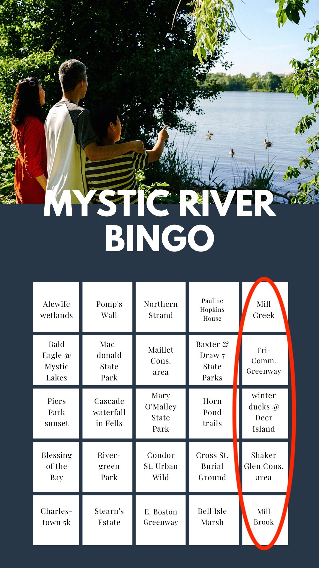

Though the competition is over—you can still play BINGO with your friends and family. To see the inspiration for the BINGO sites, see the and the African American Trail Project, MyRWA’s Greenways Progress map and MyRWA’s new Explore Map.
LOCATIONS
Alewife Constructed wetlands | Alewife is located behind, you guessed it—Alewife MBTA station. This constructed wetland is designed to store floodwater during heavy storms, but also provides a beautiful, scenic oasis in the middle of a city hub. Go here to walk on wooded boardwalks, discover wildlife, and see a great example of nature-based flooding solutions. Details | Directions | Park at the Alewife Reservation DCR Parking or the Alewife MBTA station. You can also bike here from the Minuteman Bikeway.
Mill Creek Riverwalk | Mill Creek and connecting Chelsea Creek are important habitats for both marine life and shorebirds—plus, a Atlantic herring and American eel spawn here. These boardwalks provide a quiet escape. Details | Directions
Northern Strand Trail | The Northern Strand Trail starts as a paved trail in Everett extending all the way to Lynn. The path we recommend for now is along the beautiful Malden River. Details | Directions | Easy to enter from Medford St. and Canal St. in Malden. You can take the trail past the new Rivergreen Park and to Teddie Peanut Butter and Night Shift Brewing.
Pauline Hopkins House | Pauline Elizabeth Hopkins was a pioneering journalist, feminist, novelist and playwright whose work addressed black history, racial discrimination, economic justice, and women’s role in society in late-1800’s America. Visit her home in Cambridge and read the plaque installed by the African American Trail Project. We should all know this critical history—learn more by checking out the African American Trail Project map. Details | Directions to the plaque.
Mill Brook and Wellington Park | For decades the Town of Arlington explored the feasibility of a linear park along Mill Brook, an important ecological feature in town. After years of collaboration phase one of the park renovation, climate resilience, is complete. Check it out to see the new path, boardwalk and native plantings. Details | Directions | Park across from the Wellington Tennis Courts.
Bald Eagles Mystic Lakes | As the River Herring eco-success story at the Lakes unfolds, Bald Eagles, Osprey, Striped Bass, American Eel, muskrats and hundreds of migrating ducks now visit the Lakes each year too. You’ll likely see Bald Eagles just above the Medford Boat Club. Details | Directions | Park at the Tufts Bacow Sailing Pavilion (linked in directions).
Torbert Macdonald State Park | Macdonald Park is one of the largest riverfront parks in Greater Boston. Visit to climb the tower and see skyline views, or check out recent improvements to the park—like DCR’s newly repaved bike paths, or MyRWA’s tree ID map and swallow boxes installed in 2019. Details | Directions | Park in the lot adjacent to Mystic Valley Parkway and the State Police station.
Maillet Conservation area | The headwaters of the Mystic begin in Reading and you’ll walk along side it—the Aberjona River—at Maillet Conservation Area. Beautiful in the snow, this short walk makes a great break from your routine. Details | Directions | Limited parking space at entrance, we’ve parked at Austin Preparatory School on Aberjona Rd. with success.
Sylvester Baxter Riverfront Park to Draw Seven State Park | A beautiful path passing through the Assembly Row amphitheater along the river, Baxter State Park eventually terminates where Draw Seven State Park begins. By visiting this site you’ll walk along freshwater, see the Amelia Earhart Dam and the saltwater portion of the Mystic River. Details for Baxter, Details for Draw Seven | Directions | Park at Assembly Row.
Tricommunity Greenway | The goal of this path network is to connect or create greenspace from Recreation Park in Stoneham to Horn Pond in Woburn, and Wedgemere Station in Winchester and many small parks in between. Some spots are very wide for mixed use—Think of it as a small version of the Rose Kennedy Greenway in Boston! You can take this path all the way to the Mystic Lakes. Details | Directions | We recommend hopping on at the Bacon Street entrance behind Wedgemere MBTA station, adjacent to Ginn Field (linked), and taking the path up as far north as Horn Pond in Woburn.
Piers Park | Completely saltwater, Piers Park allows for great Boston Harbor views. Visit at sunset for an incredible Boston skyline show. Details | Directions
The Cascade waterfall in the Middlesex Fells | Did you know there’s a waterfall in our watershed? This time of year it’s frozen—and we’d argue the best time to see it. The waterfall flows into a brook that goes on to join the Malden River, which joins the Mystic River and flows into the sea. Details | Directions | Very limited parking on the end of Goodyear Ave. You can also walk from the MBTA Oak Grove MBTA station (15 min) to Goodyear Avenue.
Mary O’Malley State Park | A lightly-trafficked park with phenomenal views of the Tobin Bridge in the early morning, O’Malley State Park also offers saltwater adjacent paths and lots of open space for sports. Details | Directions
Horn Pond | The terminus of the river herring migration, Horn Pond offers acres of wooded trails and lots of bird habitat. Walk the loop here—equipped with binoculars if you have them. Details | Directions
Deer Island Treatment Plant | Yes, this is the water treatment plant. No, it’s not gross. This pathway is absolutely stunning and this time of year you may see Snowy owls and migrating ducks. Details | Directions
Brooks Estate, Pomp’s Wall | An enslaved man called “Pomp” built this wall–now known as the “slave wall”–on Grove Street in 1765 for slave owner Thomas Brooks. The wall formed part of a decorative entrance to Brooks’ house. We should all know this critical history—learn more by checking out the African American Trail Project map. Details | There is no formal parking for Pomp’s Wall, but you can bike or drive along approximately 58-168 Grove St. in Medford to spot and view the wall.
Blessing of the Bay State Park | Blessing of the Bay is in the heart of the watershed. Stop here to relax by the water or jump into our 5K loop. Details & MyRWA 5K map
Rivergreen Park | A gorgeous new park along the Everett side of the Malden River. The path abuts the water and you can see the new boat launch. A great place to check out the Malden waterfront! Details | Directions
Cross St. Burial Ground now located at Oak Grove Cemetery | Cross Street is the eternal resting place of a free black family, the Revalyons, who prospered in white middle class society for more than 40 years. We should all know this critical history—learn more about the family by checking out the African American Trail Project map. Details | Directions
Condor St. Urban Wild | Here is a great example of meditative green space in a highly urbanized part of the watershed. Walk the labyrinth or watch the cargo ships pass. Details | Directions
Shaker Glen Conservation area | Shaker Glen is a densely wooded area on the Shaker Glen Brook. A pond and cattail marsh are located at the lower portion of the glen and an evergreen forest with eastern hemlocks, red cedars, and white pines runs along the northern bank. Shaker Glen is considered by many to have the finest hemlock grove in Massachusetts. Details | Directions & Parking
Charlestown | For a tour of Bunker Hill monument and unique flavors of Charlestown, walk our 5K loop. You’ll pass through residential neighborhoods and city-feel alike—just be prepared for big hills. Details found in the Charlestown 5K route (found on page 7-8) | Easiest way to find the loop is to start at the Bunker Hill Monument. Directions
Belle Isle Marsh | Did you know this is the last remaining salt marsh in Boston Harbor? Or that this space is critical habitat for migrating shore birds? Visit Belle Isle for a glimpse into important wetland habitat—and what the watershed would have looked like before development. Plus, there’s a great view of the city. Details | Directions
East Boston Greenway | The East Boston Greenway stretches from the waterfront, near Piers Park, and continues on towards Constitution Beach in Orient Heights. See rail lines, freight cars indicative of it’s rail cargo origins and view new community murals. Details | Directions There are many points to hop on the Greenway including near Maverick MBTA station and Piers Park (Marginal Street entrance).
The Stearns Estate, Secret 6 | The Stearns Estate was waystation on the Underground Railroad, a haven for slaves seeking freedom. It’s easy to miss. Hundreds of students and locals walk by it every day, but slow down to read the plaques. Today, the memory of the Stearns Estate lives on only in the name of Stearns Avenue and on the plaque in front of Cousens Gym. Learn more by checking out the African American Trail Project map. Details | Directions