RIVER HISTORY
Cities change rivers. This is certainly true of the Mystic River and surrounding watershed, which is one of the most urbanized areas in New England. Initially this river was tidal, and much of the lower watershed was salt marsh. Every spring it was filled with herring, and the Massachusett, Nipmuc, and Pawtucket people called it home. As it became more populated people began to change the river--damming it in three locations, as well as filling land in multiple areas from Island End to Medford (when I-93 was built). At the same time, industry used the river to power mills, and unfortunately at times dump dangerous chemicals.
Formally incorporated in 1972, the Mystic River Watershed Association was started with a collaboration between the Tufts Department of Chemical Engineering administration, faculty and graduate students and local activists (Peter Braun and Herbert Meyer). For much of its history, MyRWA was an all volunteer organization helping with the clean-up of local hazardous waste, and the protection of nearby wetlands. Though we still depend on volunteers, MyRWA now has a professional staff that are working to protect and restore the Mystic River watershed.
PAST AND CURRENT INDIGENOUS HERITAGE: the ‘MissiTuk’
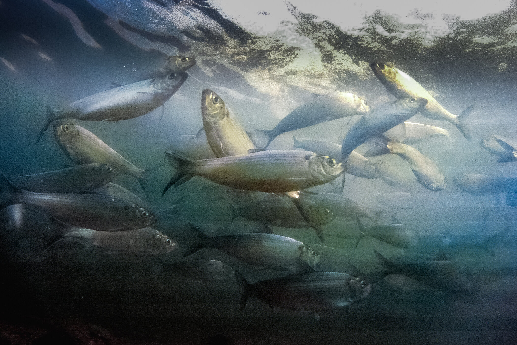
River herring in the Mystic. PC: Patrick Herron
MyRWA wishes to honor and acknowledge the indigenous communities native to this region and its past, present, and future. To our knowledge, the watershed is on the colonized lands of the Massachusett, Nipmuc, and Pawtucket tribes. The name “Mystic” comes from the term that these tribes used for the river — “Missi-Tuk,” which means “great tidal river.” As you explore the watershed, we encourage you to learn with us about its past and current indigenous heritage (Resources). River herring (a.k.a. Alewives) have been and continue to be an important part of indigenous life in this area.
1631: “Blessing of the Bay”
European colonists arrived four hundred years ago. The first ship built by Europeans in Massachusetts, named The Blessing, launched from the shores of the Mystic River at Blessing of the Bay Park in Somerville. Shipbuilding on the Mystic dates from earliest Colonial times and peaked in the 1840’s. Schooners and sloops transported timber, molasses for rum distilleries, and other products, along the trade route between Medford and the West Indies. Later, railroads and then a system of roadways replaced the River as a transportation route.
"Blessing of the Bay" was lithographed in the USA and was copyright to Donald Art Co., Inc. in 1965. Hunter Wood was born in 1908, spending much of his time in Long Island where he painted.
1734: Slades Mill
“Tide-Mills in New England” by Alfred Elden in Old-Time New England, XXV, no. 4, April 1935
Tidal mills were built along the Mystic River to harness waterpower to grind grain and spices, saw wood, and process textiles. Built to grind corn and tobacco, Slades Mill is among the first built in MA. More information can be found in the Old Time New England volume containing the article and images here. Read more about Slades Mill at the Tide Mill Institute link here.
19th Century: Clipperships
A South East View of ye Great Town of Boston in New England in America, by William Burgess, 1743
By the 19th century, 10 shipyards along the Mystic River built over 500 clipper ships. Known for their incredible speed, clipper ships became popular for international trade. Shipbuilding peaked in the 1840s as schooners and sloops transported timber and molasses for rum distilleries between Medford and the West Indies. [1]
1877: marshes filled
All the grey areas on the map show how much of the Mystic River was coastal marshes.
When later settlers filled in these marshes for industrial and residential development, they knew about typical storm flooding, but they never contemplated climate change or sea level rise. Now that our weather is changing for the worse, these are the areas that are at risk of flooding chronically without intervention.
1917-1934: Circus in town
Photo: Leslie Jones (1886-1967)
Elephants bathing salt water Mystic River Everett, MA while circus was at Sullivan Sq. grounds.[1] According to the book “Boston’s Orange Line,” by Andrew Elder and Jeremy C. Fox, a circus visited the Sullivan Square park grounds in Charlestown every year around Bunker Hill Day. The elephants were taken down to the Mystic River in Everett to cool off. The Orange Line, which ran from Sullivan Square to its terminus at the Everett Station, rides above. The book speculates that the photo was taken between 1919, when the elevated line was extended to Everett, and the mid-1930s, when Boston Mayor Frederick Mansfield banned traveling carnivals.[2]
1956-1963: Interstate 93
Construction of Interstate 93 narrowed and straightened the course of the Mystic River. 1955 (left); 1969 (right).
1966: Amelia Earhart Dam
The Amelia Earhart Dam. Photo Credit: David Mussina
The dam converted surrounding salt marsh into freshwater marsh to allow further development on the coast. It was built in 1966 to regulate tidal effects and the incursion of salt water in the upstream river basin. It has 3 locks for marine traffic. The largest is 325 feet long, and 45 feet wide; the two smaller locks are 120 feet long and, 22 feet wide.[1] There is no public access to the dam.
The dam is named after the aviation pioneer Amelia Earhart whose plane disappeared in 1937. Earhart lived in nearby Medford, Massachusetts in the 1920s. There are additional dams upstream at Winchester Falls and at Horn Pond in Woburn.
1970-1972: Mystic River Watershed Association
Photo Credit: David Mussina
In the early 1970’s Tufts University undergraduate students obtained water samples in the Mystic River and a tributary, the Aberjona River; collected other data; and analyzed the grim implications. An observer thought that the students had done something good and that it was essential that the work continue. The first thought, reported Herb Meyer the next day, was to create “an informal Mystic River Basin conservation committee before the summer recess. The Articles of Organization were “deemed to have been filed” with the Secretary of the Commonwealth and were approved thus starting the non-profit organization.
2012: Fish Ladder Installed at the New Mystic Lakes Dam
This fish ladder allows river herring to make it to the Upper Mystic Lakes—thereby increasing the spawning ground for this important fish by a factor of 1.6. Prior to that volunteers formed a bucket brigade to lift herring from the Lower to the Upper lake. In 2017 a fish ladder was installed at Center Falls dam allowing the river herring to make it to Horn Pond in Woburn. An improved passages is underway there. Read about the amazing return of the herring.
2022: myrwa celebrates 50 years
Fifty years since its creation in 1972 as an all-volunteer organization, the Mystic River Watershed Association has grown into a dynamic, membership- and grant-funded powerhouse – deeply connected to the 21 communities it serves in the watershed with 1,000 plus supporters, 17 members of the Board, 14 paid staff, thousands of volunteers, and a budget of over $4M – focused on protecting our water, restoring important habitat, building climate resilience, transforming parks and paths, and inspiring youth and community members. Read more about founding and recent history here or check out this article that highlights success through the last five decades.


